


By Matt Bayman

At some time between 256 and 330 million years ago, when Ohio and North America were part of one giant supercontinent called Pangaea, and the Appalachian Mountains were still in their infancy, a giant asteroid or comet struck southern Ohio.
The projectile punched a hole in the ground 5-to-9 miles wide and, according to archaeoastronomer William Romain in his paper “LiDar Image of the Serpent Mound Impact Crater,” devastated most life within a radius of 58 square miles.
The impact, and the blinding light that came with it, would certainly have been noticed by creatures living in what would one day become western Ohio, which were mostly amphibians and reptiles at this time, but no dinosaurs yet.
The land that the projectile hit was essentially an ancient, dried up seabed made of thick, horizontal layers of limestone, shale and sandstone. These layers formed in Ohio’s early history when the state was flooded by a series of shallow seas that covered and then receded from the region. Over hundreds of millions of years, sediment that washed into these seas from the land, and the creatures that lived and died in them, fell to the bottom of the sea and eventually formed these layers of rock that go thousands of feet down throughout much of Ohio.
When the asteroid or comet struck southern Ohio (largely in what is now Adams County), it crushed these layers of rock and sent pieces of earth flying out in all directions. It also upended huge layers of rock and created a giant cone of earth in the middle of the impact zone and a massive ring around it.
As quoted in the Cleveland Plain Dealer in an article about the impact crater from 1997, retired Ohio state geologist Michael Hansen said the area “suffered utter chaos” with 7 cubic miles of rock being smashed. It was determined that the damage to the rock strata reached down at least one mile below the surface and caused sedimentary rocks to stand on end to a depth of 700 feet. Deeper rocks were “ground up to fine flour.” At the center of the impact, the earth uplifted “at least 1,000 feet above its normal position.” For comparison, that’s as tall as the Chrysler Building in New York City!
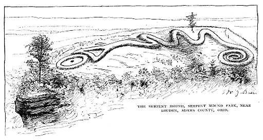
Fast-forward many millions of years, and a group of Native Americans we call the Moundbuilders decided to build one of their most important earthworks—Serpent Mound—on the western quadrant of the impact crater. This is why, today, the crater is known as the Serpent Mound Impact Crater. It is one of only 28 confirmed impact craters in the United States and the only one in Ohio. It is also considered the most unusual geological feature on the surface of the state.
All photos and images either by the author or in the public domain.


- DID THEY KNOW? -
It is debated whether the Moundbuilders, who lived in Ohio from 1,000 B.C. to 1,000 A.D., chose the site of Serpent Mound because of the peculiarity of the landscape, or for other reasons. It is likely they would have noticed the drastic changes in the landscape, but whether they understood how it got that way is doubtful.
When Ohio was first surveyed in the 1800s, the area was noted as being unusual, but no one knew why. Not much at all was known about impact craters on Earth at this time, so different theories were put forth to explain the anomalies in Adams County.
In 1838, John Locke visited and observed the area, writing“…it became evident that a region of no small extent had sunken down several hundred feet, producing faults, dislocations and upturning of the layers of rocks…it is evident that this mountain at some remote period of time, has sunk down from its original place, and I venture to call it the ‘Sunken Mountain.’”
Locke believed that tectonic forces had warped the land and created the “sunken mountain.” However, in the 1920s, scientists began to favor a cryptovolcanic origin. They envisioned that at some point in the distant past a volcanic eruption disturbed the land from below, creating the sunken effect.
Not until recently, with modern technology, was it determined that a meteor or comet impact was the likely culprit. One of the smoking guns in this argument is the presence of shatter cones in the area. Shatter cones are clusters of fan-shaped patterns (pictured below) that form in rocks (usually limestone) as a result of high-pressure, high-velocity shockwaves. One of the only ways they form on Earth is from powerful meteor and comet impacts. (We didn’t know this until astronauts brought back rocks from the Moon for comparison). This evidence, along with the advent of flight, satellites, radar imaging and Google Earth, which clearly show the impact zone, has solidified the argument and it is now widely accepted.


- VISITING THE IMPACT CRATER -
Although millions of years of erosion have washed much of the crater away, to this day it is possible to visit the impact zone and to see evidence of this catastrophic event from Ohio’s deep past.
One such way is to purchase a field guide from the Ohio Department of Natural Resources (ODNR) called “Guide to the Serpent Mound Impact Structure, South-Central Ohio.” (It is available online HERE) Written by Ohio University geologist Keith Milam, the 34-page booklet contains in-depth information about the impact crater (its geology and history) and a self-guided tour (with maps, directions and descriptions) of nine places where evidence of the impact crater can be seen. This includes visiting an unusual outcrop that is found nowhere else in Ohio, driving across the central peak of the crater, and exploring the Serpent Mound Historical Site, which is located in the “ring trough” of the impact zone next to Brush Creek, and that contains a few mysteries of its own.
In “LiDar Image of the Serpent Mound Impact Crater,” Romain puts forth the idea that Serpent Mound was built where it is exactly because of the unique landscape. He suggests that the Moundbuilders may have beleived that the disturbed land represented the place where the Great Serpent came up from the underworld and moved across the Earth, possibly renewing the world each time it did so.
As a plaque at the Serpent Mound Historical Site states: “In the traditions of many American Indian tribes, the Great Serpent was a powerful spirit. People could call upon the Great Serpent for the power to cure-illnesses or to be successful in hunting animals.”
The serpent effigy, Romain suggests, was built on top of this unique and sacred place to honor this spirit. It depicts a serpent swallowing an egg or oval, which traditionally symbolizes renewal or rebirth in Native American religion. (No one knows for sure what the circle represents)
What is even more interesting here is that Serpent Mound was built on top of a rock outcrop (inside of the impact zone) that resembles the body and head of a snake (pictured below), and that contains several small caves. In Native American legend, caves were believed to be portals to the underworld, as was water.


- SERPENT MOUND HISTORICAL SITE -
The Serpent Mound Historical Site is one of the nine stops in the ODNR guide, and definitely the most interesting. Here, especially in the winter and early spring, when the foliage is missing, visitors can take a hike on the Brush Creek Nature Trail (located behind the Visitor’s Center) and clearly see the rock “body” and “face and mouth” of the “snake” outcrop and the caves that the earthwork sits upon. This is something that most visitors don’t take advantage of, or are unaware of. It is even possible to stand directly beneath the effigy. Sometimes, especially around the solstices and equinoxes, Native Americans visit the sacred site and sing songs and play flutes in the area, as heard in several videos posted below this article.
Near this location, hikers will come across an unusual pillar-shaped stone (pictured below right). It’s not like any other stone in the area. Nobody knows if it was fashioned by humans as a pillar or just a natural rock formation that fell to the forest floor from above. However, researcher Ross Hamilton, who wrote the book, The Mystery of the Serpent Mound, believes the pillar once stood erect inside of the egg part of the effigy up above. The snake’s mouth and the egg point to the summer solstice sunset on the distant horizon (located just outside of the impact zone). Maybe the pillar, Hamilton suggests, acted like the sight of a rifle barrel that marked the place on the horizon where the sun sets on the longest day of the year, which is a time of celebration and spiritual importance for Native Americans. Hamilton’s theory is backed by the fact that the first surveyors to visit Serpent Mound noted “large stones” near the oval/egg part of the effigy, several of which were arranged in a circle.
If true, this means that, until Europeans arrived and scattered the stones on the hillside, part of Serpent Mound may have been made of stone.
It also means that, by chance or intuition, the Moundbuilders built Serpent Mound on top of a rock outcrop that resembles a snake, which happens to point toward the summer solstice sunset, on top of a strange geological feature that resembles the hole of a snake coming out of the ground, which emulates the place where the Great Serpent emerges from the underworld to renew the world…and it also has caves and is next to a river! The whole area of the impact crater and Serpent Mound, then, is like a microcosm inside of a microcosm.
Another interesting mystery to ponder at the historic site—this time at the effigy up above—is evidence of a missing coil (see video at bottom of page) that once existed near the head of the serpent.
A plaque at this location notes that in 2012, Dr. Jarrod Burks, from Ohio Valley Archaeology, Inc., conducted a magnetic gradient survey at Serpent Mound and discovered a U-shaped feature near the neck of the serpent that “appears to represent an ancient surface buried by an embankment that was later removed.” It continues, “If this interpretation is correct, then at some time in the past, the original builders of Serpent Mound, or perhaps a later group, changed the design of Serpent Mound. Why they might have done this is a mystery.”


- SERPENT MOUND BY KAYAK -
Another unique and lesser-known way to explore the Serpent Mound Historical Site—and the impact crater—is by kayak.
This can be done by using a public access point for Brush Creek located just a few hundred feet from the main entrance to Serpent Mound on Ohio Route 73. From here, kayakers can paddle upstream (in mostly still water) for about 500 yards to reach the banks of the historical site. Along the way, the river follows a series of steep cliff walls (pictured below) that begin to form the “body” of the rock outcrop that Serpent Mound sits upon. These impressive cliffs can only be seen by the public from the water. The land on the other side of the river is private property and can not be accessed.
A small cobble beach acts as an unofficial river access point to the Serpent Mound Historical Site. From here, visitors are near the base of the effigy outcrop (and its head) and directly in front of a sizable and somewhat intimidating-looking cave. A short walk through the woods from this location leads to the Brush Creek Nature Trail, which provides access to the Serpent Mound Historical Site and attractions up above. (Note: There is a fee to enter the historical site and can be paid at the Visitor’s Center.)
When kayaking Brush Creek, one is largely paddling through the trough zone of the impact crater. This is the flat area located between the central cone and the outer rim of the crater.


- MODERN MYSTERIES -
Mysteries are not just a thing of the past at the Serpent Mound Impact Crater.
According to writer Thomas Johson in his article “Crater at Serpent Mound,” the Serpent Mound Impact Crater is the only known place on Earth where an object from space has collided with a rift or fault in the Earth’s surface. Because of this, he writes, magnetic anomalies occur across the crater area and have a direct effect on the weather, causing severe storms to dissipate as they approach the rim of the impact zone. “Local residents tell of the batteries on vehicles and cell phones being mysteriously drained,” Johson writes. Residents and visitors also report that compasses don’t work properly while in the impact zone.
Once again, it is not known if the Moundbuilders noticed any of these anomalies in their own day-to-day lives.
.jpg)
- DRIVING ACROSS THE HEART OF THE CRATER -
Ohio Route 41 passes through the eastern side of the impact zone and directly between the central peak and the crater rim. If you’re driving south on Route 41, after the small town of Sinking Springs, the outer rim of the crater will be on your left.
Just a few miles south of Sinking Springs, on your right, is Parker Ridge Road. This mix of gravel and pavement road crosses directly through the central peak of the impact and, thus, the place where the comet or asteroid actually hit the ground.
Hansen said in the Cleveland Plain Dealer article that there is likely no trace of the asteroid or comet fragment in the ground, as it “most likely vaporized on impact.”
The highest peak in the area is located on private property and requires permission to visit (see the ODNR guide), as does a nearby creek where layers of ancient rocks can be seen standing on end. However, when there is little foliage on the trees and ground, drivers on Parker Ridge Road will notice they are traveling across a central hill that is surrounded by an outer rim of other hills. The road is at its highest as you approach the intersection with Walnut Grove Road. A private residence near this location has a fitting sign at the end of their driveway that reads, “Top of the Ridge.”
Not far from this location is Stop #8 on the ODNR tour, which explores a roadside exposure of breccia (pictured below right).
Breccia is like a giant mass of different rocks that appear to be melted or jumbled together. Slices of the rock look like slices of fruit cake (pictured below left)! It is rare to find in Ohio. They form from high-pressure events and are commonly associated with impact craters, but not always. In this case, the breccia outcrop is located near the central peak, which means it got hot enough to melt the existing rocks together. Milam believes there are 22 such breccia exposures in the Serpent Mound Impact Zone, but nowhere else in Ohio.
Following the specific directions provided in the ODNR guide, tourists can park on the side of the rural road at Stop #8 and view the breccia exposure up-close. The exposure is on Horner Chapel Road, which Parker Ridge dead-ends into when coming from Route 41.


- STANDING ON THE RIM OF THE CRATER? -
One of the most striking views of the impact crater (from the ground) is at Locust Grove Cemetery (pictured above), which is another stop on the ODNR tour and the final stop in this article.
Located on Route 41, Locust Grove Cemetery is situated on a tall hill to the south of the impact zone. By driving to the top of the hill, visitors can see a panoramic view of the crater zone. From this vantage point, the central peak of the crater is on your left and what Milam refers to as a “suspiciously circular” segment of hills in the distance, i.e. the outer rim of the crater is straight ahead and to your right.
While geologists agree on the impact theory, the size of the impact zone is still being debated. While some geologists favor the 5-mile-in-diameter model, Milam favors a larger area. In fact, in the ODNR guide, he suggests that, when standing on top of the cemetery hill, you’re actually on a small island of land that once stood on the southernmost rim of a giant 9-mile-wide crater, which is pretty wild!
Even if you’re not a geologist, visiting this area by car, foot and even kayak, and with the ODNR guide or not, is a fascinating experience filled with mystery, beauty and wonder.
To purchase a copy of the “Guide to the Serpent Mound Impact Structure, South-Central Ohio,” call the Geologic Records Center at (614) 265-6576. (It is available online for free HERE)
Watch a video about the Impact Crater HERE.
Additional reading at https://ohiodnr.gov/static/documents/geology/RI146_Baranoski_2003.pdf
The "pillar" at Serpent Mound. Some people believe it once stood in the oval/egg of the serpent effigy up above. The camera pans up to the "head/face" of the rock formation upon which Serpent Mound is built. This was filmed on June 22, 2021 and several Native Americans happened to be at the effigy at the same time. This is the singing, chanting and flute playing you can hear in some of these videos.
(Videos by Matt Bayman)
Standing beneath the "head" of the rock outcrop and serpent effigy.
The "body" of the snake/rock outcrop, leading up to the cave. Listen for Native American flutes at the cave.
There is evidence of a "missing" coil at Serpent Mound.
Kayaking beneath Serpent Mound in the morning. The effigy itself is located on the hillside up above.
Closer to the kayak launch point near Serpent Mound.
A look at the "pillar" and "snake head" without foliage.
Learn more about the mysteries of Serpent Mound HERE.